 |
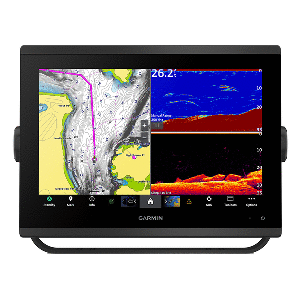
Garmin GPSMAP® 1243xsv Combo GPS/Fishfinder GN+ FREE SHIPPING available for this item when using UPS Ground. Model #: 010-02367-61 Description: Garmin GPSMAP® 1243xsv Combo GPS/Fishfinder GN+ . Youre an angler who wants premium features, maps, and charts for your connected helm, plus built-in sonar. This crisp 12" high-resolution chartplotter makes that wish come true.Get a sharper view from your connected helm with the GPSMAP® 1243xsv chartplotter. With its high-resolution 12 in-plane switching display, ultra-sleek design, and vivid sonar color palette, it seamlessly integrates into your Garmin marine system. GPSMAP 1243xsv also features built-in Ultra High-Definition SideVü and ClearVü scanning sonars and supports 1 kW CHIRP traditional sonar as well as fully networkable radar and live sonar devices. Preloaded Garmin Navionics+ coastal charts and inland mapping feature Auto Guidance+ technology (Auto Guidance+ is for planning purposes only and does not replace safe navigation operations) for helping you get where you need to go. Plus, theres support for optional Garmin Navionics Vision+ premium map content. Easily build your marine system from compatible sonar and autopilots to compatible radar, cameras, and multimedia by using HTML 5.0, NMEA 2000® and NMEA 0183 network connectivity, J1939 for engines, and the Garmin Marine Network. Or pair your plotter with your other compatible Garmin devices, such as quatix® marine smartwatches, wind transducers, wireless remote controls, and more. Features: High-resolution in-plane switching touchscreen display offers improved sunlight readability and wide-angle visibility over previous-generation 12 units Fast and responsive, this robust GPSMAP® system references 10 Hz GNSS (GPS, GLONASS, and Galileo) for accurate positioning and smooth speed as well as COG data Slimline display borders, edge-to-edge glass, and reduced unit footprint make for easy retrofit in a wider range of dash configurations Preloaded Garmin Navionics+ coastal charts and inland mapping feature Auto Guidance+ technology (Auto Guidance+ is for planning purposes only and does not replace safe navigation operations); plus, theres support for optional Garmin Navionics Vision+ premium map content. J1939 engine connectivity for easy integration with engines and our exclusive OneHelm feature for connecting to your compatible third-party devices, such as EmpirBus digital switching Easily build your marine system from compatible sonar and autopilots to compatible radar, cameras and multimedia by using NMEA 2000® and NMEA 0183 network connectivity and the Garmin Marine Network Use built-in Wi-Fi® networking to pair with the free ActiveCaptain® smartphone app for access to the OneChart feature, smart notifications, software updates, and more. Integrated ANT® connectivity support for use with your compatible quatix® marine smartwatches, gWind Wireless 2 transducer, GNX Wind marine instrument, and wireless remote controls Built-in Ultra High-Definition SideVü and ClearVü scanning sonars with high-contrast vivid color palettes to help distinguish fish from structure Supports live sonar devices, 1 kW CHIRP traditional sonar, and more What's In The Box? Chartplotter microSD preinstalled Power cable NMEA 2000 T-connector NMEA 2000 drop cable Bail mount with knobs Flush mount kit with gasket Protective cover Trim piece snap covers Documentation GPSMAP x3 chartplotters are preloaded with Garmin Navionics+ offshore, coastal, and inland water charts for the U.S. and Canada Shipping Weight: 11.7 lbs. Retail Price: $2999.99 Our Price: $2999.99 Contact Us Phone: 305-444-3911 Fax: 305-444-3912 Email: info@marinewholesales.com |
|